
Mt Tauhara Walking Track
NOTE: The entire track (includes the mountain) is on PRIVATE LAND. Please respect the privilege of being able to use the land. Don't leave litter and don't disturb stock. Keep to the route. No dogs, firearms, or lighting of fires are permitted. If you need to use a gate then you probably will not make it to the top.
VEHICLE ACCESS: Up to the end of the sealed section of Mountain Road (950m from SH5).
ROUTE: Refer to the map and photos. Grid lines are 1km apart on the map.
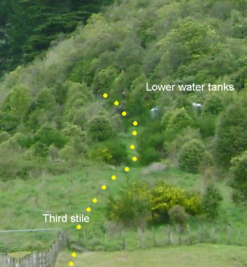
After leaving the vehicle park (550m above sea level), follow the dirt road 50m. Cross two stiles and follow the marked route on the farm up the ridge. You will meet a fence which you travel beside. Cross the third stile (665m) then head up to the green water tanks (698m).
These tanks are partially obscured by the bushes, but the track on the ground is easy to follow. You are about one third up when you reach the bushline (upper green tank). The next third is fairly steep (no worse than the farm bit), but cooler in the bush. Some good views can be seen of Taupo. Have a rest on the seat (847m) which is about the half way point. When you reach the stream (982m) you are about two thirds up.
The last third is the easiest section. After leaving the stream you'll encounter a 25m long narrow cutting through pumice from the last Taupo eruption (130 AD). This is about 2.5m deep. There is an alternative path beside the cutting. You will emerge by a small clearing (1009m). From here you can see the summit trig to the east.
When you have reached the top (trig point) you will be rewarded with magnificent views of the Central North Island. If it isn't too hazy you will see the line of volcanoes stretching from Mt Ruapehu in the SW to White Island in the NE, Lake Taupo, and the vast pine plantations of the Kaingaroa and Lake Taupo forests.
You may like to walk along the summit ridge for 160m to some large rocky boulders (probably not recommended for young children).
TIME: About 1.5 to 2 hours to climb up - quicker down. Allow longer with younger children.
TAKE: Drinks, snacks, sturdy walking shoes, warm clothing (+ hat). It can be windy and cold at the top even on a beautiful day. Expect the summit to be a minimum of 5°C cooler than the carpark.
ABOUT MT TAUHARA: Mt Tauhara is a dormant volcano. It has numerous vents. You will see a quarry on the eastern side of the mountain where dacite is extracted. This is used in roading and some of the large decorative boulders in and around Taupo.
The summit is 1088m above sea level.


Base map insert courtesy of LINZ
(from NZTopo50-BG36 version 2).
GPS track and waypoint data: Jim Lewis
Note: The LINZ topo map (version 2) does not show the track.
Version 1 does show the track but the actual route is not correct.
Version 2-02 has the track correctly shown
Visitors: